These pages are a technical guide for solar PV system inspection via manned aircraft. Inspection guidance for unmanned aerial systems (i.e., drones) is available here. Inspection contract specifications for PV system owners and operators are also available here.
Why Inspect Solar Systems with Manned Aircraft?
Manned aircraft can serve as a viable option for inspecting solar PV systems under certain circumstances. Mobilization costs may be minimized using manned aircraft when inspecting solar farms in close proximity of each other. Large solar farms, where drone pilots are unable to maintain visual line of site (VLOS) of their drone, are a suitable use-case for manned aircraft. They are good when solar systems are located in areas where airspace restrictions prohibit drone operations. Certain environmental conditions such as high winds or high temperatures can also necessitate the use of manned aircraft as they are more equipped than drones to handle environmental extremes.
Fixed or single-axis ground mount and roof-mounted solar arrays are ideal for manned aircraft solar inspection. This is largely due to the consistent angle at which an entire solar array is oriented, making it easy to adjust the gimbal pitch to avoid glare.
⚠️Conversely, manned aircraft solar inspections are not compatible with solar arrays mounted on dual-axis trackers. Dual axis trackers are able to rotate to better track the sun throughout the day on its X-axis (East to West) as well as on its Y-axis (North to South). The variation of tracker angles when inspecting this type of array makes it difficult to identify whether elevated heat signatures are caused by electrical defects or increased glare.
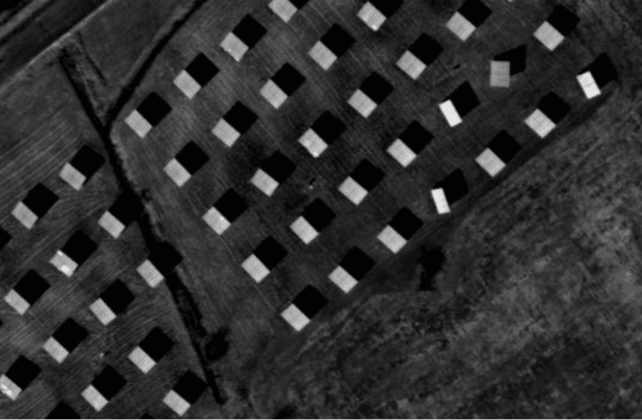
Example of solar array mounted on dual-axis trackers shown in greyscale infrared.
Terminology
Manned aircraft are those operated by an onboard, human pilot. Airplanes and helicopters are examples, but this designation also includes gliders and balloons. Inclusive terminology, such as “piloted” has not seen widespread adoption in the industry. This term can also be confusing as UAS are also piloted. Therefore, we adhere to the term “manned aircraft” in this document.
Fixed-wing aircraft are propeller or jet-driven and have wings.
Rotary aircraft are lifted by rotating blades. In this document, we use rotary aircraft and helicopter interchangeably.
Unmanned aerial systems (UAS) refer to the entire system of an aircraft (or multiple aircraft), onboard flight controllers, the ground station to send commands and operators. The terms sUAS is used to designate “small” UAS, under 55 lb.
Drones is the common term for unmanned aerial systems (UAS). In this document, we adhere to the term drone.
CFIs are Certified flight instructors.
Data collection specialist refers to the non-pilot member of the crew. The data collection specialist is responsible for ensuring a complete dataset captured according to the correct specifications.
Camera setup describes the thermal imaging system, mounting system, power distribution, camera control system and data storage.
Sensor specifically refers to the thermal camera detector, excluding the optical elements (e.g., lenses) and other parts of the camera.
Infrared is the portion of the spectrum with a wavelength beyond red. Mid-wave infrared (MWIR) is 3–8 μm wavelength, while long-wave infrared (LWIR) 8–15 μm, also known as the “thermal imaging” region.
Thermal is used interchangeably with infrared.
Radiometric is used to distinguish the physical properties of the thermal detector, as opposed to post-processing enhancements.
Strafing is the ability to move a camera independent of an aircraft.
Above ground level (AGL) refers to an aircraft’s altitude relative to the ground directly below.
Mean Sea level (MSL) refers to an aircraft’s altitude above the average sea level, which makes it a constant value.