Note: The solar farm must be fully energized during the aerial PV thermography inspection. Raptor Maps will not be able to provide analytics for areas of the solar farm that were not energized during the aerial PV thermography inspection.
Thermal Imagery
All IR inspections require Obliques to be flown. For more information on how to capture Obliques, see here.
Ground Sample Distance
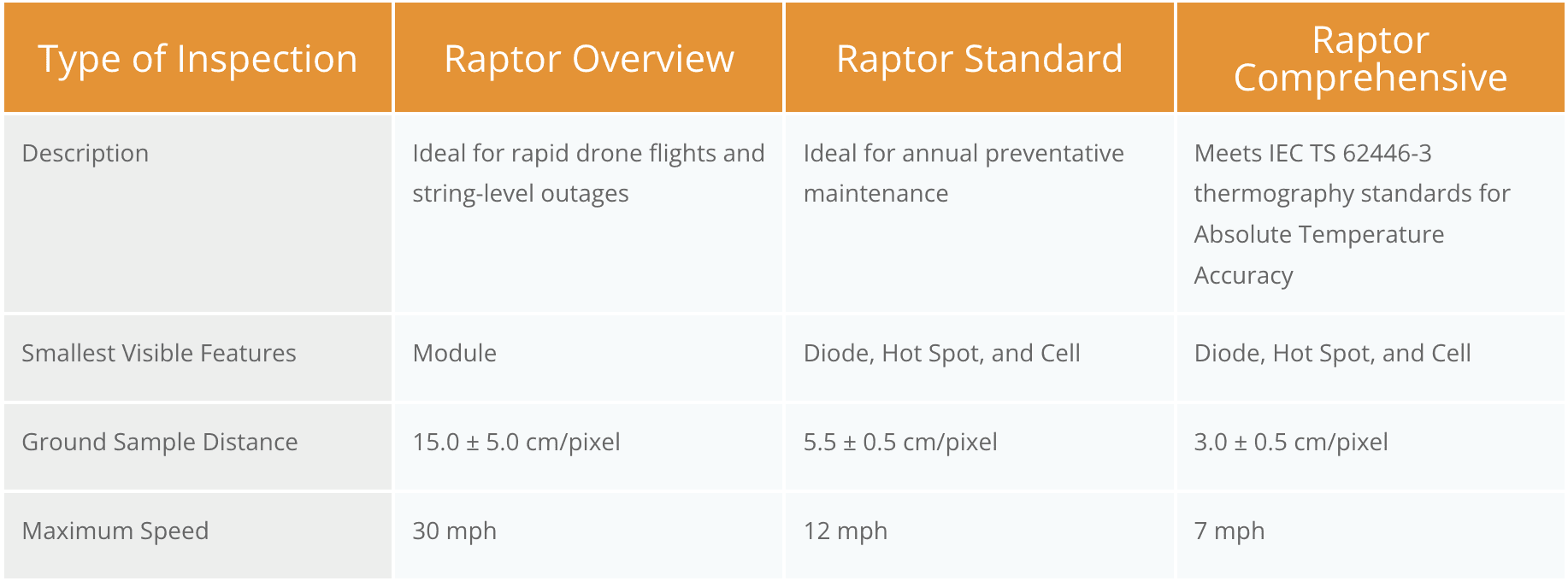
Image Resolution
640×512 pixels or greater.
Field of View
Horizontal field of view 30-50 degrees.
Gimbal Pitch
Perpendicular to solar modules. See this video for more information.
Overlap
70% front overlap (direction of flight) and 20% side overlap.
Image Alignment
The horizontal edge of the image aligns with the long edge of the solar rows.*
*See special instructions for fixed-wing drones
File Format
Radiometric JPEG (R-JPEG).
Metadata must contain GPS location, relative altitude, gimbal pitch, gimbal yaw, gimbal roll and timestamp. Do not include split IR/RGB imagery when uploading data to Raptor Maps.
Image Quality
Imagery must be free from motion blur.
Imagery must contain minimal glare.
Visible (RGB) Imagery
Ground Sample Distance
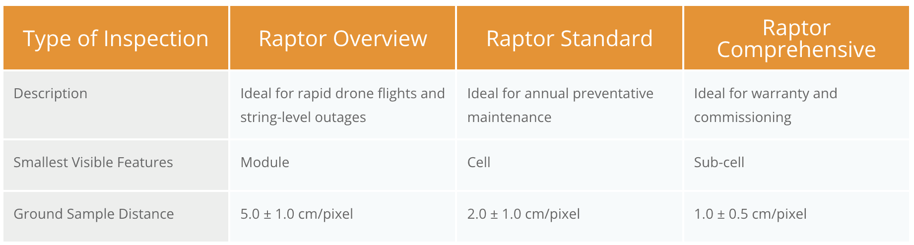
Image Resolution
4000×3000 pixels or greater.
Field of View
50 degrees or greater.
Gimbal Pitch
Nadir (straight down) with deviation up to 20 degrees acceptable (to avoid glare).
Overlap
70% front overlap (direction of flight) and 20% side overlap.
Image Alignment
The horizontal edge of the image aligns with the long edge of the solar rows.*
*See special instructions for fixed-wing drones.
File Format
JPEG
Metadata must contain GPS location, relative altitude, gimbal pitch, gimbal yaw, gimbal roll and timestamp.
Image Quality
Imagery must be free from motion blur.
Imagery must contain minimal glare.
Environmental Conditions
Do NOT fly within 2 hours of sunrise or sunset.
Clear skies and sunny or slightly overcast
Irradiance greater or equal to 600 Watts per square meter
We recommend irradiance meter use to confirm sufficient irradiance.
If requested, pilots will be required to supply Raptor Maps with images proving POA irradiance from a sensor. If pilots cannot prove irradiance was above 600 Watts per square meter throughout the flight, a reflight will be required.
Humidity ideally less than 60%
Wind below 6.7 m/s (15 MPH)
Data Capture Rates
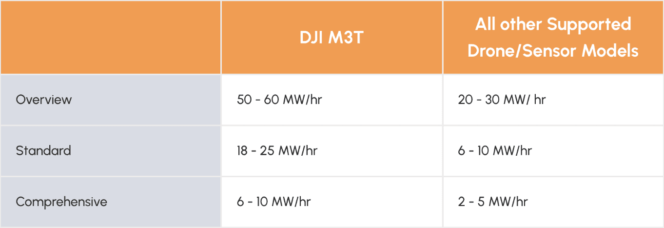
These numbers only account for true flight time, they do not factor in drone setup, battery swaps, checklists, etc.
Special Considerations
In the event that an inverter, combiner, or other large piece of equipment is offline, pilots must wait at least a 30 minutes after re-energization of this equipment before conducting any aerial thermography inspection. Irradiance must be >600W/m2 in this time period and remain >600W/m2 during the flight.
In the event that during an aerial thermography flight irradiance drops below 600W/m2, the pilot must pause the inspection and wait 5 minutes after the irradiance returns to >600W/m2 prior to resuming the mission.
Sensor Heading
For both IR and RGB inspection-level imagery sets, sensor heading must remain fixed throughout the flight. For example, if flying a fixed-tilt, ground mount site with panels facing south, the sensor should face North throughout the flight.
Maintaining a fixed sensor heading may require manual intervention by the Pilot in Command depending on the flight software in use. Reference the videos in our specific flight operations guidelines for more information.
Base Layer Imagery
An additional data set is required to collect base layer imagery if the site is less than 1 year old and/or no satellite imagery is available.
Same requirements as RGB Imagery except the following deviations.
Ground Sample Distance
5.0 ± 1.0 cm/pixel.
Gimbal Pitch
Nadir (straight down) with deviation up to 10 degrees acceptable (to avoid glare).
Overlap
70% front overlap (direction of flight) and 70% side overlap.
Uploading Data
All data should be uploaded the same day the flight occurs. For flights that take place over multiple days, the data should be uploaded the same day it is captured.