Getting Started
Information to Provide
Uploading Data
Raptor App
Raptor Mobile App
Instant Inspections
Instant Inspections - Data Notes
Aerial Thermography Ops — Drones
Aerial Thermography Ops — Manned Aircraft
DJI M30T Flight Guidelines
DJI M30T Flight Guidelines
DJI M30T Flight Guidelines
DJI M30T Flight Guidelines
DJI M30T Flight Guidelines
Flight guidelines for inspecting solar farms with a DJI M30T.
Flight guidelines for inspecting solar farms with a DJI M30T.
Flight guidelines for inspecting solar farms with a DJI M30T.
Flight guidelines for inspecting solar farms with a DJI M30T.
Flight guidelines for inspecting solar farms with a DJI M30T.
Search…
Equipment
Drone: DJI M30T
Camera: Built-in
Computer: Smart Controller
Flight Planning Software: DJI Pilot 2

Please ensure the super resolution for the thermal imagery is not enabled. Additionally, there are some zoom sync options that enable the thermal camera to digitally match the zoom of the RGB camera. Please ensure these are turned off (or set to 1x).
Sensor Heading
For both IR and RGB inspection-level imagery sets, sensor heading must remain fixed throughout the flight. For example, if flying a fixed-tilt, ground mount site with panels facing south, the sensor should face North throughout the flight. Datasets, where sensor heading alternates with each flight pass (sensor faces North one flight pass and South on the next flight pass), will warrant a reflight.
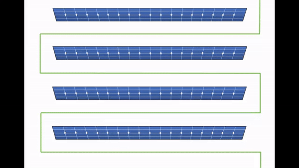
Image Capture
Front Overlap Ratio: 70%
Side Overlap Ratio: 20%
File Format: RJPG
Obliques
Note: Obliques / High flys are required as part of the flight. For information about how to correctly fly and take oblique images, please see Capturing Oblique Images.
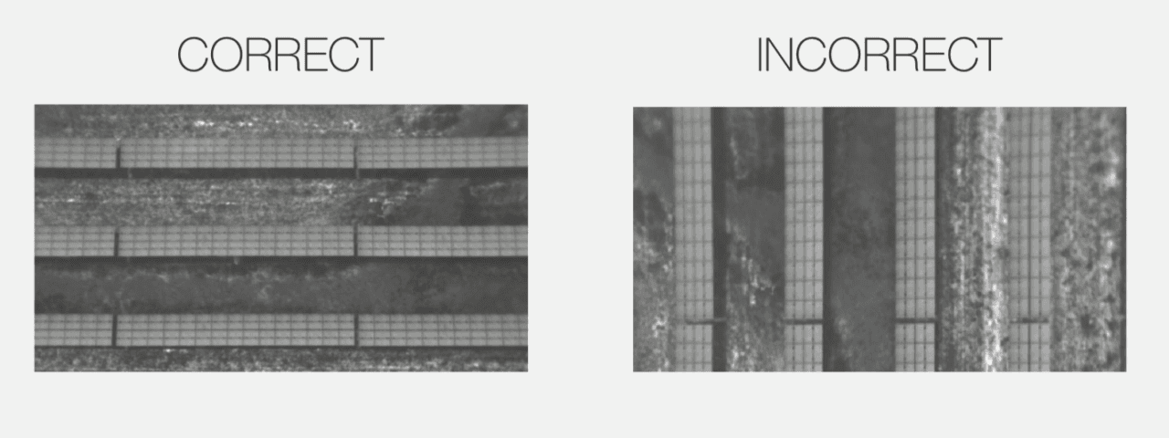
Data Example
The long edge of the solar row aligns with the long edge of the image.
More to come!
Links & Support
Stay Up to Date
Subscribe to our newsletter and stay informed about innovations in solar asset optimization, deploying robotics for solar, our research and testing with OEMs, the latest in our product development, and more.
Links & Support
Stay Up to Date
Subscribe to our newsletter and stay informed about innovations in solar asset optimization, deploying robotics for solar, our research and testing with OEMs, the latest in our product development, and more.
Links & Support
Stay Up to Date
Subscribe to our newsletter and stay informed about innovations in solar asset optimization, deploying robotics for solar, our research and testing with OEMs, the latest in our product development, and more.
Links & Support
Stay Up to Date
Subscribe to our newsletter and stay informed about innovations in solar asset optimization, deploying robotics for solar, our research and testing with OEMs, the latest in our product development, and more.
Links & Support
Stay Up to Date
Subscribe to our newsletter and stay informed about innovations in solar asset optimization, deploying robotics for solar, our research and testing with OEMs, the latest in our product development, and more.