With more solar projects coming online and aging assets requiring attention, the pressure to do more with less is only increasing. And too often, teams lack visibility when they need it most.
This quarter’s updates focus on solving exactly that. We’re helping teams:
See what’s happening on-site faster for asset oversight and management
Take the right action, at the right time with precision intelligence
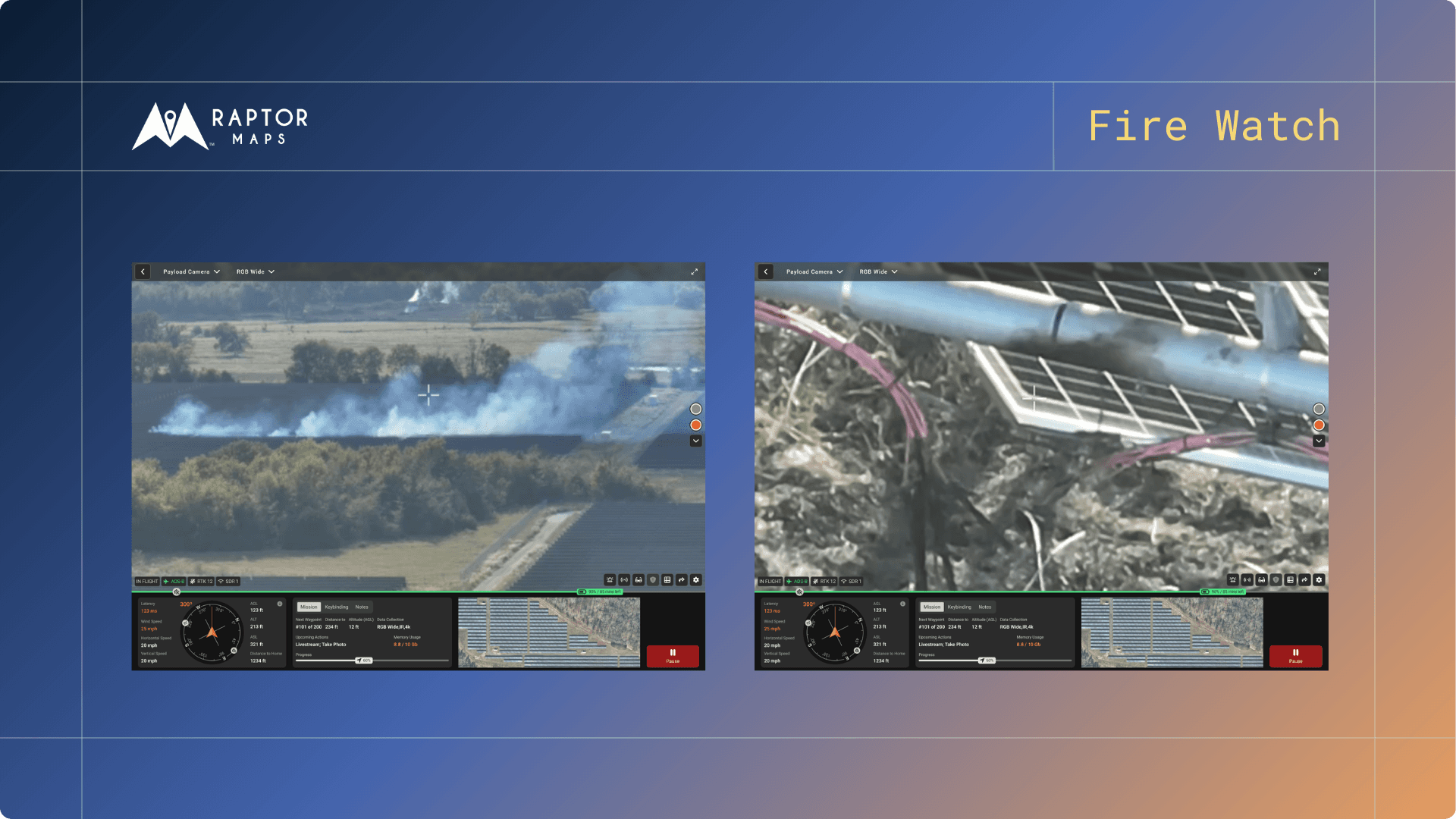
Livestream: Real-time Visibility, Literally
Similar to a SCADA system communicating with sensors and smart devices to collect data, Raptor Solar Sentry provides a remote visual monitoring solution that sends remote commands to drones and other robotics installed on-site in order to collect data, either as real-time livestream or as high definition imagery for analysis. In other words, users are able to get on-demand livestreams as the remotely commanded drone flies around specific areas of interest on the solar farm and provide you real-time vision into anywhere on your solar farm.

If you are using a remotely commanded drone (a.k.a. “docked drone” or “drone-in-a-box”), the drone is housed and protected in weather-resistant docks that enable missions as soon as conditions begin to clear up. Using remote livestreams as a first response also improves safety by reducing technician exposure to potentially hazardous conditions.
Learn more on our upcoming webinar (April 19th) here.
20 Different Inspection Order Options
Pictures can be worth a thousand insights, especially when it comes to operating and maintaining physical infrastructure like solar farms. That is why we are continuing to expand our Inspection Analytics suite and making it easier for customers to get inspection insights across a wide variety of aspects of their solar farm without requiring manual human inspections. Based on the subscription type, users can now select orders from an expanded menu of options, such as “(Agrivoltaics) Animal Assessment”, “Erosion”, “Meteorological Station Inspections”, “Perimeter Monitoring”, and more. Relatedly, Sentry customers can determine a schedule of inspections repeated on a regular cadence from the expanded menu of options.

Expanded Erosion and Vegetation Monitoring Analytics
Q1 also marked a significant expansion of our visual analytics capabilities for civil and environmental compliance and preventative maintenance, transforming traditionally manual inspection processes into automated, data-driven workflows. The visual data collected is converted into quantified, actionable insights to prioritize action.
Our enhanced Erosion Monitoring now delivers precise risk assessment across seven distinct categories, quantified into low-, medium-, and high-risk classifications. This includes new capabilities for monitoring road conditions and BMP (Best Management Practice) impacts - enabling proactive maintenance before issues become costly problems. Check out category definitions here.
To support SWPPP compliance efforts and uncover evidence of any variation from the Plan, we've also introduced the SWPPP Plan Comparison functionality, allowing users to overlay their SWPPP drawings directly onto identified issues and associated imagery. Coupled with more regular data collection through Sentry, you can intuitively compare how conditions change over time and how they compare to your SWPPP plans.

We’ve also expanded Raptor Maps’ Vegetation Monitoring capabilities. First, the platform now supports behind-the-panel inspections to identify and tag vegetation growth behind panels, providing owners and operators with a critical new insight into managing fire risk on-site. Second, we are now able to monitor vegetation height at inverter blocks, providing more up-to-date intel to prioritize mowing needs on the asset. Similar to how erosion or drainage issues are marked as color-coded polygons on the Digital Twin, vegetation height is also represented through polygons on the map.
Access the Data You Need, How You Need It
The Raptor Solar platform aggregates and normalizes data into an objective source of truth that persists throughout the lifetime of a solar asset, functioning as a clean system of record that drives more effective communication and collaboration across stakeholders. Q1 updates also focused on making it easier for you to get the data you need, how you need it.
We've streamlined how you interact with the data by introducing a toggle between the Digital Twin Map View, Summary Table View of each inspection, and the Site Dashboard that functions as mission control for managing activities and performance on each asset. This update eliminates the need for you to navigate to different parts of the platform, while enabling you to maintain filters as you move between the Map and Table views.

The map-based Digital Twin provides an intuitive interface for interacting with the data and insights, enabling more efficient decision-making and action. As a geospatial digital reconstruction of the asset granular down to the equipment-level, the Digital Twin hosts a tremendous amount of data regarding each asset. For users of the Mobile App working on tasks on-site, the latest quality-of-life improvements to the Mobile App Digital Twin include enhanced data loading logic and a new search functionality for task owners, streamlining the way teams navigate and update information in the field. As an Offline-first Mobile App, users can flexibly download only the data they need, allowing them to use the App’s GPS and other features while on sites with no cell signal.
Lastly, we shipped updates to our data export and API capabilities. CSV exports now include Anomaly Lifecycle Status and location, and the CSVs are exportable through the Web App or through the API. Endpoints were also added to enable PDF exports through the API.
————
Not yet a customer? Schedule time with us to discuss how we can help you hit your KPIs and operational goals.
Next steps
From the civil engineering on your site down to the wiring on the back of your panels, the Raptor Solar platform provides you detailed, up-to-date data on the conditions and performance of your solar fleet so that your team has the intel they need to do their jobs effectively, quickly, and safely.